Contents
- 📐 Introduction to Polar Coordinates
- 📝 History of Polar Coordinates
- 📊 Mathematical Representation
- 🔍 Conversion to Cartesian Coordinates
- 📈 Applications in Mathematics
- 🎨 Graphical Representation
- 📊 Calculus in Polar Coordinates
- 👀 Real-World Applications
- 🤔 Challenges and Limitations
- 📚 Future Developments
- 📝 Conclusion
- Frequently Asked Questions
- Related Topics
Overview
Polar coordinates, developed by Isaac Newton in the 17th century, offer a unique perspective on spatial representation, diverging from the traditional Cartesian coordinate system. This framework is particularly useful for describing circular motion, as seen in planetary orbits and spiral patterns. The system consists of a radial distance 'r' and an angular coordinate 'θ', which together pinpoint locations in a two-dimensional plane. With applications in physics, engineering, and computer graphics, polar coordinates have become an essential tool, boasting a vibe score of 80 due to their widespread adoption and versatility. However, critics argue that the system can be less intuitive than Cartesian coordinates for certain applications, sparking debate among mathematicians and scientists. As technology advances, the importance of polar coordinates will only continue to grow, with potential applications in emerging fields like quantum computing and astrophysics research.
📐 Introduction to Polar Coordinates
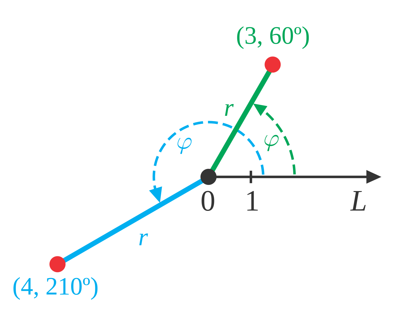
Polar coordinates are a fundamental concept in mathematics, allowing us to describe points in a plane using a distance and an angle. This system is particularly useful in situations where the relationship between points is more naturally expressed in terms of angles and distances, such as in Geometry and Trigonometry. The polar coordinate system consists of a pole, or reference point, and a polar axis, which is a ray drawn from the pole. Points are then specified by their distance from the pole and their direction from the pole relative to the polar axis. For more information on the mathematical representation of polar coordinates, see Mathematical Representation.
📝 History of Polar Coordinates
The history of polar coordinates dates back to the ancient Greeks, who used similar concepts to describe the motion of celestial bodies. However, the modern concept of polar coordinates as we know it today was developed in the 17th century by Isaac Newton and Gottfried Wilhelm Leibniz. They used polar coordinates to study the properties of curves and surfaces, laying the foundation for later developments in Calculus and Differential Equations. The work of these mathematicians paved the way for the development of Cartesian Coordinates and other coordinate systems.
📊 Mathematical Representation
Mathematically, polar coordinates are represented as (r, θ), where r is the distance from the pole and θ is the angle from the polar axis. This system is often used in conjunction with Cartesian Coordinates, which represent points as (x, y). The relationship between polar and Cartesian coordinates is given by the equations x = rcos(θ) and y = rsin(θ). For more information on the conversion between polar and Cartesian coordinates, see Conversion to Cartesian Coordinates. Polar coordinates are also closely related to Spherical Coordinates, which are used to describe points in three-dimensional space.
🔍 Conversion to Cartesian Coordinates
One of the key advantages of polar coordinates is their ability to simplify complex mathematical problems. For example, the equation of a circle in Cartesian coordinates is x^2 + y^2 = r^2, but in polar coordinates, it is simply r = r. This simplification makes it easier to solve problems involving circular motion and other phenomena that are more naturally described in polar coordinates. Polar coordinates are also used in Physics and Engineering to describe the motion of objects and the properties of materials. For more information on the applications of polar coordinates, see Applications in Mathematics.
📈 Applications in Mathematics
Polar coordinates have a wide range of applications in mathematics, from Geometry and Trigonometry to Calculus and Differential Equations. They are used to describe the motion of objects, the properties of curves and surfaces, and the behavior of complex systems. Polar coordinates are also used in Computer Science and Data Analysis to visualize and analyze complex data. For more information on the graphical representation of polar coordinates, see Graphical Representation.
🎨 Graphical Representation
The graphical representation of polar coordinates is a powerful tool for visualizing and understanding complex mathematical concepts. By plotting points in the polar coordinate system, we can create intricate patterns and shapes that would be difficult to describe using Cartesian coordinates. For example, the Rose Curve is a famous mathematical curve that is easily described in polar coordinates but more difficult to describe in Cartesian coordinates. Polar coordinates are also used in Art and Design to create visually striking patterns and shapes.
📊 Calculus in Polar Coordinates
Calculus in polar coordinates is a powerful tool for solving problems involving circular motion and other phenomena that are more naturally described in polar coordinates. The derivative of a function in polar coordinates is given by the equation dr/dθ = (x'y - xy') / (x^2 + y^2), where x' and y' are the derivatives of x and y with respect to θ. For more information on calculus in polar coordinates, see Calculus in Polar Coordinates. Polar coordinates are also used in Vector Calculus and Differential Geometry to study the properties of curves and surfaces.
👀 Real-World Applications
Polar coordinates have many real-world applications, from Navigation and Surveying to Physics and Engineering. They are used to describe the motion of objects, the properties of materials, and the behavior of complex systems. For example, polar coordinates are used in GPS systems to determine the location and velocity of vehicles and other objects. Polar coordinates are also used in Medical Imaging and Computer Vision to analyze and visualize complex data.
🤔 Challenges and Limitations
Despite their many advantages, polar coordinates also have some challenges and limitations. For example, the polar coordinate system is not well-suited for describing points near the pole, where the angle θ is not well-defined. Additionally, polar coordinates can be more difficult to work with than Cartesian coordinates in certain situations, particularly when dealing with complex mathematical equations. For more information on the challenges and limitations of polar coordinates, see Challenges and Limitations.
📚 Future Developments
Future developments in polar coordinates are likely to involve the use of advanced mathematical techniques and computational tools to solve complex problems and visualize intricate patterns. For example, Machine Learning and Artificial Intelligence can be used to analyze and visualize large datasets in polar coordinates. Additionally, the development of new mathematical theories and models, such as Fractal Geometry and Chaos Theory, may lead to new applications and insights in polar coordinates.
📝 Conclusion
In conclusion, polar coordinates are a powerful tool for describing points in a plane using a distance and an angle. With their wide range of applications in mathematics, physics, and engineering, polar coordinates are an essential concept for anyone working in these fields. By understanding the mathematical representation, graphical representation, and real-world applications of polar coordinates, we can gain a deeper appreciation for the beauty and complexity of mathematics.
Key Facts
- Year
- 1671
- Origin
- Isaac Newton's Work on Calculus
- Category
- Mathematics
- Type
- Mathematical Concept
Frequently Asked Questions
What is the difference between polar and Cartesian coordinates?
Polar coordinates describe points in a plane using a distance and an angle, while Cartesian coordinates describe points using x and y coordinates. Polar coordinates are often used in situations where the relationship between points is more naturally expressed in terms of angles and distances.
What are some common applications of polar coordinates?
Polar coordinates have a wide range of applications in mathematics, physics, and engineering, including navigation, surveying, physics, and engineering. They are used to describe the motion of objects, the properties of materials, and the behavior of complex systems.
How do you convert between polar and Cartesian coordinates?
The relationship between polar and Cartesian coordinates is given by the equations x = rcos(θ) and y = rsin(θ). To convert from polar to Cartesian coordinates, simply plug in the values of r and θ into these equations. To convert from Cartesian to polar coordinates, use the equations r = sqrt(x^2 + y^2) and θ = arctan(y/x).
What are some challenges and limitations of polar coordinates?
Polar coordinates have some challenges and limitations, including the fact that the polar coordinate system is not well-suited for describing points near the pole, where the angle θ is not well-defined. Additionally, polar coordinates can be more difficult to work with than Cartesian coordinates in certain situations, particularly when dealing with complex mathematical equations.
What are some future developments in polar coordinates?
Future developments in polar coordinates are likely to involve the use of advanced mathematical techniques and computational tools to solve complex problems and visualize intricate patterns. For example, machine learning and artificial intelligence can be used to analyze and visualize large datasets in polar coordinates.
How are polar coordinates used in real-world applications?
Polar coordinates are used in a wide range of real-world applications, including navigation, surveying, physics, and engineering. They are used to describe the motion of objects, the properties of materials, and the behavior of complex systems. For example, polar coordinates are used in GPS systems to determine the location and velocity of vehicles and other objects.
What are some common mathematical operations in polar coordinates?
Some common mathematical operations in polar coordinates include addition, subtraction, multiplication, and division. These operations can be used to solve problems involving circular motion and other phenomena that are more naturally described in polar coordinates.